Kód: 10000657
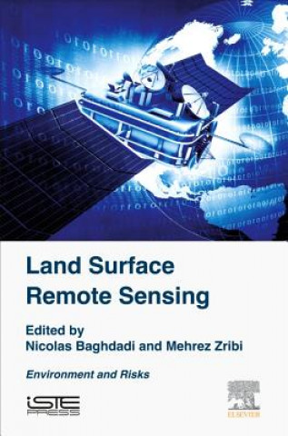
Land Surface Remote Sensing
Autor Nicolas Baghdadi, Mehrez Zribi
Land Surface Remote Sensing: Environment and Risks explores the use of remote sensing in applications concerning the environment, including desertification and monitoring deforestation and forest fires. The first chapter covers th ... celý popis
- Jazyk:
 Angličtina
 - Vazba: Pevná
- Počet stran: 384
Nakladatelství: ISTE Press Ltd - Elsevier Inc, 2016
- Více informací o knize

Mohlo by se vám také líbit
-

House Industries Lettering Manual (new edition)
617 Kč -

Seven Stones to Stand or Fall
420 Kč -

Crowley Thoth Tarot Deck
702 Kč -

Danganronpa 2: Ultimate Luck And Hope And Despair Volume 2
387 Kč -

Bruce Lee Jeet Kune Do
425 Kč -

de Gaulle
654 Kč -

Spawn: Origins Volume 1 (New Printing)
221 Kč -

The Nightmare Before Christmas Tarot Deck and Guidebook
518 Kč -

Viking Art
434 Kč -

Dokkaebi: Vicious Spirits
286 Kč -

Unlock Level 3 Reading, Writing, & Critical Thinking Student's Book, Mob App and Online Workbook w/ Downloadable Video
1131 Kč -

Mythographic Color and Discover: Dream Garden
367 Kč -

How to use graphic design to sell things, explain things, make things look better, make people laugh, make people cry, and (every once in a while) cha
1078 Kč -

Final Fantasy XIV: A Realm Reborn - The Art of Eorzea -Another Dawn-
910 Kč -

Classic Tale of Peter Rabbit Board Book (the Revised Edition)
226 Kč -

Radiant Tarot
950 Kč -

Kid A Mnesia
804 Kč -

Civilization
409 Kč -

Space Mathematics
427 Kč -

Art of Big Hero 6
887 Kč -

Maths Made Easy: Beginner, Ages 8-9 (Key Stage 2)
117 Kč -

HSK Standard Course 2 - Textbook
813 Kč -

Complete Chord Songbook
479 Kč -

Design Patterns for Embedded Systems in C
1809 Kč -

Ancient Guide to Modern Life
303 Kč -

Origins of Order
3813 Kč -

Starting out: King's Indian
592 Kč -

The Geography of Thought
357 Kč -

ROSE GARDEN LG ADDR BK
355 Kč -

Goodnight Moon
204 Kč -

Battling the Gods
303 Kč -

Nelson Mini-Bücher: 4er Disney Die Eiskönigin 2 5-8
130 Kč -

Der kleine Prinz - Le Petit Prince
720 Kč -

Ściąga liceum, technikum Część 1 Antyk, Średniowiecze, Renesans, Barok, Oświecenie
102 Kč -

Das geheime Leben der Bäume
319 Kč -

Die verlorene Ehre der Katharina Blum
250 Kč -

Das große MZ-Buch
783 Kč -

Gedichte * Dithyramben
592 Kč -

Mein kunterbuntes Soundbuch - Tiere
421 Kč -

Vow of Thieves
546 Kč -

Helmut Newton, autobiografía
700 Kč -

(27)Original HSP TV-Ein Schwesterchen Für Onchao
307 Kč
Dárkový poukaz: Radost zaručena
- Darujte poukaz v libovolné hodnotě a my se postaráme o zbytek.
- Poukaz se vztahuje na celou naši nabídku.
- Elektronický poukaz vytisknete z e-mailu a můžete ihned darovat.
- Platnost poukazu je 12 měsíců od data vystavení.
Více informací o knize Land Surface Remote Sensing
Nákupem získáte 494 bodů
 Anotace knihy
Land Surface Remote Sensing: Environment and Risks explores the use of remote sensing in applications concerning the environment, including desertification and monitoring deforestation and forest fires. The first chapter covers the characterization of aerosols and gases by passive remote sensing. The next chapter presents the correlation of optical images for quantifying the deformation of the Earth's surface and geomorphological processes. The third chapter is examines remote sensing applications in the mining environment. The fourth chapter depicts the strong potential of radar imagery for volcanology and urban and mining subsidence studies. The next two chapters deal respectively with the use of remote sensing in locust control and the contribution of remote sensing to the epidemiology of infectious diseases. In the last ten years, spatial observation of the Earth—particularly continental surfaces—has expanded considerably with the launch of increasing numbers of satellites covering various applications (hydrology, biosphere, flow of surface, snow, ice, landslide, floods). This has paved the way for an explosion in the use of remote sensing data. This book offers essential coverage of space-based observation techniques for continental surfaces. The authors explore major applications and provide a corresponding detailed chapter for the physical principles, physics of measurement, and data processing requirements for each technique, bringing you up-to-date descriptions of techniques used by leading scientists in the field of remote sensing and Earth observation. Provides clear and concise descriptions of modern remote sensing methodsExplores the most current remote sensing techniques with physical aspects of the measurement (theory) and their applicationsProvides chapters on physical principles, measurement, and data processing for each technique describedDescribes optical remote sensing technology, including a description of acquisition systems and measurement corrections to be made
 Parametry knihy
Zařazení knihy Knihy v angličtině Earth sciences, geography, environment, planning Earth sciences Geology & the lithosphere
4940 Kč
- Plný název: Land Surface Remote Sensing
- Podnázev: Environment and Risks
- Autor: Nicolas Baghdadi, Mehrez Zribi
- Jazyk:
 Angličtina
 - Vazba: Pevná
- Počet stran: 384
- EAN: 9781785481055
- ISBN: 1785481053
- ID: 10000657
- Nakladatelství: ISTE Press Ltd - Elsevier Inc
- Hmotnost: 530 g
- Rozměry: 229 × 152 × 25 mm
- Datum vydání: 10. October 2016
Oblíbené z jiného soudku
-

Reading the Rocks
386 Kč -

Nature and Properties of Soils, The, Global Edition
2294 Kč -

Past Time: Geology in European and American Art
1064 Kč -

S & S Guide to Rocks and Minerals
582 Kč -

Structural Geology
1688 Kč -

Sea without Fish
983 Kč -

Geological Field Techniques
1934 Kč -
Soil Science Simplified 6e
2720 Kč -

Lost World of Fossil Lake
967 Kč -

Pleistocene Boundary and the Beginning of the Quaternary
2413 Kč -
Stable Isotope Geochemistry
2720 Kč -

H2O
303 Kč -

Mycorrhizal Planet
772 Kč -

Story of Earth
347 Kč -
Geology For Dummies
483 Kč -

True Truffle (Tuber spp.) in the World
7468 Kč -

Annals of the Former World
598 Kč -

Environmental Chemistry
3747 Kč -
Radon: A Tracer for Geological, Geophysical and Geochemical Studies
7468 Kč -
The Geology of Kuwait
1135 Kč -

Medical Geology
1973 Kč -

Anthropocene: A Very Short Introduction
254 Kč -

Ice Age
1967 Kč -

Brief History of Geology
1054 Kč -

Rocks: A Very Short Introduction
269 Kč -

Glaciation: A Very Short Introduction
249 Kč -
Geology: A Very Short Introduction
249 Kč -

Making of Europe
904 Kč -

Mineral Resources, Economics and the Environment
1949 Kč -
Timefulness
1013 Kč -

Historical Geology
2137 Kč -
Global Geomorphology
2170 Kč -
Principles of Geology, Volume 1
802 Kč -

Plate Tectonics: A Very Short Introduction
269 Kč -

Igneous and Metamorphic Petrology 2e
3610 Kč -

Landscapes and Geomorphology: A Very Short Introduction
269 Kč -

Ore Deposit Geology
2006 Kč -

Soil and Environmental Chemistry
3144 Kč -
Tectonic Geomorphology 2e
2976 Kč -
Fossils: A Very Short Introduction
269 Kč -

Earth on Show
1621 Kč -

Quaternary Paleoenvironments - Submerged Landscapes of the European Continental Shelf.
3338 Kč -

Last Giant of Beringia
700 Kč -

Pleistocene
6578 Kč -
Earth: An Introduction to Physical Geology, Global Edition
2339 Kč -

White River Badlands
1036 Kč -

Principles of Geology, Volume 2
1874 Kč -

Principles of Geology, Volume 3
1874 Kč -
Geomorphology
2646 Kč
Osobní odběr Praha, Brno a 12903 dalších
Copyright ©2008-24 nejlevnejsi-knihy.cz Všechna práva vyhrazenaSoukromíCookies


 Vrácení do měsíce
 571 999 099 (8-15.30h)