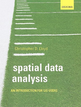
Kód: 01323410
Spatial Data Analysis
Autor Christopher D Lloyd
What is the shortest route between one point and another in a road network? Where is the incidence of disease the highest? How does rainfall correlate with altitude? How does the concentration of a pollutant vary in space, and whe ... celý popis
- Jazyk:
 Angličtina
 - Vazba: Brožovaná
- Počet stran: 224
Nakladatelství: Oxford University Press, 2009
- Více informací o knize

Mohlo by se vám také líbit
-
Spatial Data Analysis
2422 Kč -

Spatial Data Analysis
2936 Kč -

Open Source GIS
5094 Kč -

New York City in 1979
90 Kč -

Suicide in Canada
1474 Kč -

Dead Man's Ransom
276 Kč -

Introduction to Spatial Econometrics
4267 Kč
Darujte tuto knihu ještě dnes
- Objednejte knihu a zvolte Zaslat jako dárek.
- Obratem obdržíte darovací poukaz na knihu, který můžete ihned předat obdarovanému.
- Knihu zašleme na adresu obdarovaného, o nic se nestaráte.
Více informací o knize Spatial Data Analysis
Nákupem získáte 168 bodů
 Anotace knihy
What is the shortest route between one point and another in a road network? Where is the incidence of disease the highest? How does rainfall correlate with altitude? How does the concentration of a pollutant vary in space, and where do high concentrations correlate with densely populated areas? Geographical or spatial data play a vital role in many parts of daily life. We are dependent on information about where things are located and about the attributes of those things, either directly, as in the use of a map for navigating around a city, or indirectly, where we use resources like water or gas. Making use of spatial data requires a whole set of approaches to extract information from those data and make them useful. Underpinning these approaches is the analysis of data. Spatial Data Analysis introduces key principles about spatial data and provides guidance on methods for their exploration; it provides a set of key ideas or frameworks that will give the reader knowledge of the kinds of problems that can be tackled using the tools that are widely available for the analysis of spatial data. The approach is gradual and systematic; the initial focus is on themes that follow through the rest of the book. These key ideas are introduced, illustrated, and restated to ensure that readers develop a clear understanding of them. Beyond careful explanations, a clear understanding is fostered still further by numerous worked examples and case studies. In short, the stress is on first principles and reinforcement of key ideas throughout - on education rather than simply training, based on the conviction that users of spatial data analysis tools should know something about how the approaches work rather than simply how to apply them. Online Resource Centre The Online Resource Centre to accompany Spatial Data Analysis features For registered adopters of the book: Figures from the book, available to download. For students: Synthetic data and worked examples to enable readers to experiment with the methods described in the book.
 Parametry knihy
Zařazení knihy Knihy v angličtině Earth sciences, geography, environment, planning Geography Geographical information systems (GIS) & remote sensing
1678 Kč
- Plný název: Spatial Data Analysis
- Autor: Christopher D Lloyd
- Jazyk:
 Angličtina
 - Vazba: Brožovaná
- Počet stran: 224
- EAN: 9780199554324
- ISBN: 0199554323
- ID: 01323410
- Nakladatelství: Oxford University Press
- Hmotnost: 452 g
- Rozměry: 245 × 189 × 13 mm
- Datum vydání: 03. December 2009
Oblíbené z jiného soudku
-

Designing Better Maps
1643 Kč -

Cartography.
1648 Kč -

Mastering Geospatial Analysis with Python
1564 Kč -

Semiology of Graphics
3423 Kč -

Geographic Information Science and Systems 4e
5566 Kč -

GIS for Science
1248 Kč -

Geocaching
479 Kč -

Introduction to Geographical Information Systems, An
2042 Kč -

Connections and Content
1284 Kč -
Focus on Geodatabases in ArcGIS Pro
1914 Kč -

Framework for Geodesign
2462 Kč -
Esri Guide to GIS Analysis, Volume 3
1447 Kč -

Springer Handbook of Geographic Information
10603 Kč -

Reconstruction and Analysis of 3D Scenes
4859 Kč -

Geoinformatics
926 Kč -

Mastering ArcGIS Server Development with JavaScript
1398 Kč -

LiDAR Remote Sensing and Applications
3343 Kč -

GIS For Dummies
992 Kč -

ArcGIS Book
771 Kč -

Python For ArcGIS
3611 Kč -

Spring Boot Messaging
1384 Kč -

GNSS - Global Navigation Satellite Systems
5985 Kč -

GIS in Land and Property Management
7887 Kč -

Spatial Statistics and Geostatistics
2135 Kč -

Programming GPS and OpenStreetMap Applications with Java
2310 Kč -

European Landscape Dynamics
6712 Kč -

Satellite Interferometry Data Interpretation and Exploitation
4814 Kč -

Introduction to GIS Programming and Fundamentals with Python and ArcGIS (R)
3664 Kč -

Error Propagation in Environmental Modelling with GIS
3966 Kč -

QGIS Python Programming Cookbook -
1564 Kč -

Learning ArcGIS Pro
1564 Kč -

GPS For Dummies 2e
634 Kč -

Mastering QGIS -
1730 Kč -

Introducing Geographic Information Systems with ArcGIS - A Workbook Approach to Learning GIS, Third Edition
3284 Kč -

Integration of GIS and Remote Sensing
6884 Kč -

Energy of Nations
1339 Kč -

Physical Principles of Remote Sensing
5223 Kč -

New Developments and Environmental Applications of Drones
5391 Kč -

GIS and Spatial Analysis for the Social Sciences
3190 Kč -

Mapping with ArcGIS Pro
1398 Kč -

Satellite Altimetry Over Oceans and Land Surfaces
7284 Kč -

Learning QGIS 2.0
788 Kč -

ArcGIS Pro and ArcGIS Online Applications in Water and Environmental Sciences
2259 Kč -

Geographic Information Systems (GIS)
8779 Kč -

Geographical Information Science
2693 Kč -

Spatial Conservation Prioritization
6105 Kč -

Digital Terrain Modelling
5094 Kč -

Thermal Infrared Remote Sensing
5362 Kč -

Conceptual Modeling for Traditional and Spatio-Temporal Applications
3313 Kč
Osobní odběr Praha, Brno a 12903 dalších
Copyright ©2008-24 nejlevnejsi-knihy.cz Všechna práva vyhrazenaSoukromíCookies


 Vrácení do měsíce
 571 999 099 (8-15.30h)