Kód: 01979003
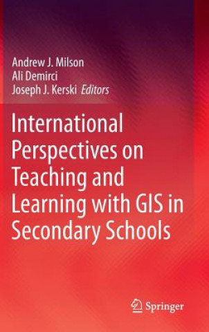
International Perspectives on Teaching and Learning with GIS in Secondary Schools
Autor Andrew J. Milson, Ali Demirci, Joseph J. Kerski
This, the first publication to collate a broad international perspective on the pedagogical value of GIS technology in classrooms, offers an unprecedented range of expert views on the subject. Geographic Information Systems (GISs) ... celý popis
- Jazyk:
 Angličtina
 - Vazba: Pevná
- Počet stran: 353
Nakladatelství: Springer, 2011
- Více informací o knize

3313 Kč

Skladem u dodavatele v malém množství
Odesíláme za 12-15 dnů
Potřebujete více kusů?Máte-li zájem o více kusů, prověřte, prosím, nejprve dostupnost titulu na naši zákaznické podpoře.
Přidat mezi přání
Mohlo by se vám také líbit
-

Theology of the Book of Genesis
1742 Kč -

Modelling of Systems with Small Observation Sets
1681 Kč -

Ready to Read - Green Line
373 Kč -

Tooth Whitening
4403 Kč -

Christopher Marlowe
9965 Kč -

Grammar to Enrich & Enhance Writing
1551 Kč -

Schwarze Haut, weiße Masken
481 Kč
Dárkový poukaz: Radost zaručena
- Darujte poukaz v libovolné hodnotě a my se postaráme o zbytek.
- Poukaz se vztahuje na celou naši nabídku.
- Elektronický poukaz vytisknete z e-mailu a můžete ihned darovat.
- Platnost poukazu je 12 měsíců od data vystavení.
Více informací o knize International Perspectives on Teaching and Learning with GIS in Secondary Schools
Nákupem získáte 331 bodů
 Anotace knihy
This, the first publication to collate a broad international perspective on the pedagogical value of GIS technology in classrooms, offers an unprecedented range of expert views on the subject. Geographic Information Systems (GISs) are now ubiquitous and relatively inexpensive. They have revolutionized the way people explore and understand the world around them. The capability they confer allows us to capture, manage, analyze, and display geographic data in ways that were undreamt of a generation ago. GIS has enabled users to make decisions and solve problems as diverse as designing bus routes, locating new businesses, responding to emergencies, and researching climate change. GIS is also having a major impact in the classroom. Students and teachers around the world are using this significant emerging technology in the secondary school classroom to study social and scientific concepts and processes, to broaden their technical skills, and to engage in problem solving and decision making about local and global issues.§International Perspectives on Teaching and Learning with GIS in Secondary Schools brings together authors from 34 countries who profile the current status of GIS in secondary school teaching and learning in their country. Each chapter includes a summary of the country s educational context, a case study illustrating how GIS is used in secondary schooling, and an assessment of the opportunities and challenges in teaching and learning with GIS now and in the future. The book demonstrates that GIS is not only a technological tool to be used in the classroom, but also a catalyst for motivation, encouragement, and cooperation in understanding and solving global problems.§The most up to date and extensive survey of GIS in the secondary education landscape, covering both principles and practice.§Professor David Maguire, Pro-Vice-Chancellor, Birmingham City University, UK§International Perspectives on Teaching and Learning With GIS in Secondary Schools is a highly relevant, critically important, reflective contribution to the literature, providing strong arguments supporting the inclusion for spatial studies for all in secondary school education. §Karl Donert, President, EUROGEO§This is an invaluable and inspirational examination of innovation in geospatial technologies in secondary schools around the world. Each chapter contains practical models for how to integrate powerful tools for spatial analysis into a range of subjects. It will be useful to classroom teachers and administrators seeking pathways to implementation and teacher educators considering how to prepare the next generation to use geospatial technologies.§Sarah Witham Bednarz, Department of Geography, Texas A&M University, College Station, TX, USAThis, the first publication to collate a broad international perspective on the pedagogical value of GIS technology in classrooms, offers an unprecedented range of expert views on the subject. Geographic Information Systems (GISs) are now ubiquitous and relatively inexpensive. They have revolutionized the way people explore and understand the world around them. The capability they confer allows us to capture, manage, analyze, and display geographic data in ways that were undreamt of a generation ago. GIS has enabled users to make decisions and solve problems as diverse as designing bus routes, locating new businesses, responding to emergencies, and researching climate change. GIS is also having a major impact in the classroom. Students and teachers around the world are using this significant emerging technology in the secondary school classroom to study social and scientific concepts and processes, to broaden their technical skills, and to engage in problem solving and decision making about local and global issues.§International Perspectives on Teaching and Learning with GIS in Secondary Schools brings together authors from 34 countries who profile the current status of GIS in secondary school teaching and learning in their country. Each chapter includes a summary of the country s educational context, a case study illustrating how GIS is used in secondary schooling, and an assessment of the opportunities and challenges in teaching and learning with GIS now and in the future. The book demonstrates that GIS is not only a technological tool to be used in the classroom, but also a catalyst for motivation, encouragement, and cooperation in understanding and solving global problems.§The most up to date and extensive survey of GIS in the secondary education landscape, covering both principles and practice.Professor David Maguire, Pro-Vice-Chancellor, Birmingham City University, UK§International Perspectives on Teaching and Learning With GIS in Secondary Schools is a highly relevant, critically important, reflective contribution to the literature, providing strong arguments supporting the inclusion for spatial studies for all in secondary school education. §Karl Donert, President, EUROGEO§This is an invaluable and inspirational examination of innovation in geospatial technologies in secondary schools around the world. Each chapter contains practical models for how to integrate powerful tools for spatial analysis into a range of subjects. It will be useful to classroom teachers and administrators seeking pathways to implementation and teacher educators considering how to prepare the next generation to use geospatial technologies.§Sarah Witham Bednarz, Department of Geography, Texas A&M University, College Station, TX, USA
 Parametry knihy
Zařazení knihy Knihy v angličtině Society & social sciences Education Schools
3313 Kč
- Plný název: International Perspectives on Teaching and Learning with GIS in Secondary Schools
- Autor: Andrew J. Milson, Ali Demirci, Joseph J. Kerski
- Jazyk:
 Angličtina
 - Vazba: Pevná
- Počet stran: 353
- EAN: 9789400721197
- ISBN: 9400721196
- ID: 01979003
- Nakladatelství: Springer
- Hmotnost: 698 g
- Rozměry: 240 × 159 × 24 mm
- Datum vydání: 27. September 2011
Oblíbené z jiného soudku
-

Jolly Phonics Activity Books 1-7
1199 Kč -

Benno Bär und das Brummdidum. Kamishibai Bildkartenset, m. 1 Beilage
472 Kč -

Montessori from the Start
419 Kč -

Columbine
373 Kč -

Einschiebefolie für das Kamishibai. Für das Schattenspiel in Kindergarten und Schule
249 Kč -

Teaching English as a Second Language
372 Kč -

My First Book of Uppercase Letters
204 Kč -
Understanding How We Learn
778 Kč -

Where's the Poop?
223 Kč -

Montessori Today
345 Kč -

Synchronicity
708 Kč -

Lifelong Kindergarten
428 Kč -

Painting at School
1400 Kč -

Planning in the Moment with Young Children
813 Kč -

Bunte Familie: Auf unserem Sofa ist für alle PlatzMix-Max-Spiel für Kinder ab 2
442 Kč -

Geometry Lessons in the Waldorf School
406 Kč -

Summerhill School
450 Kč -

Geology and Astronomy
303 Kč -

Collins International Primary Maths - Workbook 3
416 Kč -

Columbine
464 Kč -

Ten Minutes to Bed: Little Unicorn
223 Kč -

Ten Minutes to Bed: Little Monster
156 Kč -
Progress in Geography: Key Stage 3 Workbook 1 (Units 1-5)
315 Kč -

Language and Literature for the IB MYP 2
696 Kč -

Forest School in Practice
1115 Kč -

Forest School and Outdoor Learning in the Early Years
1115 Kč -

Montessori In The Classroom
521 Kč -

Teaching English to Young Learners
1107 Kč -
100 Ideas for Secondary Teachers: Outstanding Geography Lessons
508 Kč -
Learning All The Time
442 Kč -

Loose Parts
959 Kč -

Theories of Attachment
809 Kč -

Sankt Martin
371 Kč -

Games, Ideas and Activities for Primary Drama
574 Kč -

Earth Science for Waldorf Schools
608 Kč -

Target Grade 7 Edexcel GCSE (9-1) Chemistry Intervention Workbook
247 Kč -

Der größte Schatz der Welt. Kamishibai Bildkartenset
442 Kč -
Teaching Geography Creatively
1126 Kč -

Teaching Chemistry with TOYS
593 Kč -

History Teacher's Handbook
1087 Kč -
Teaching Geography
1681 Kč -

Theories of Childhood
881 Kč -

Outdoor Learning in the Early Years
1191 Kč -

Effective Leadership and Management in the EYFS
669 Kč -

Ich war das nicht!
371 Kč -

Jesus ist auferstanden. Kamishibai Bildkartenset
397 Kč -

Hase und Igel. Kamishibai Bildkartenset
348 Kč -

Teaching Poetry in the Primary Classroom
885 Kč -

What Your First Grader Needs To Know (Revised And Updated)
560 Kč
Osobní odběr Praha, Brno a 12903 dalších
Copyright ©2008-24 nejlevnejsi-knihy.cz Všechna práva vyhrazenaSoukromíCookies


 Vrácení do měsíce
 571 999 099 (8-15.30h)