Kód: 15196187
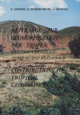
Beiträge zur Geomorphologie der Tropen
Autor F. Ahnert, H. Rohdenburg, A. Semmel
The inselberg region of Machakos is located in the south-eastern part of the highlands of Kenya, on the boundary between the exposed pre-Cambrian basement and its Cenozoic volcanic cover. The morphoclimate of this region is contro ... celý popis
- Jazyk:
 Němčina
 - Vazba: Brožovaná
- Počet stran: 140
Nakladatelství: Schweizerbart'sche Verlagsbuchhandlung, 1982
- Více informací o knize

1620 Kč
Dostupnost:
50 % šance Máme informaci, že by titul mohl být dostupný. Na základě vaší objednávky se ho pokusíme do 6 týdnů zajistit.
Prohledáme celý svět
Mohlo by se vám také líbit
-

Goethe und Schiller - ihr Leben und ihre Werke
1360 Kč -

Entwicklung der Kunst in der Stufenfolge der einzelnen Kunste
465 Kč -

Samhain
917 Kč -

Scrappy: Use Everything You Have, Trust Yourself, and Press the Reset Button for Success, the Lolly Wolly Doodle Way
817 Kč -

OLD TIME CUSTOMS: MEMORIES AND TRADITION
453 Kč -

Edinburgh Companion to the Postcolonial Middle East
7105 Kč -

QUOTES FROM THE LAKESIDE
373 Kč
Darujte tuto knihu ještě dnes
- Objednejte knihu a zvolte Zaslat jako dárek.
- Obratem obdržíte darovací poukaz na knihu, který můžete ihned předat obdarovanému.
- Knihu zašleme na adresu obdarovaného, o nic se nestaráte.
Informovat o naskladnění knihy
Zadejte do formuláře e-mailovou adresu a jakmile knihu naskladníme, zašleme vám o tom zprávu. Pohlídáme vše za vás.
Více informací o knize Beiträge zur Geomorphologie der Tropen
Nákupem získáte 162 bodů
 Anotace knihy
The inselberg region of Machakos is located in the south-eastern part of the highlands of Kenya, on the boundary between the exposed pre-Cambrian basement and its Cenozoic volcanic cover. The morphoclimate of this region is controlled by the seasonal fluctuation of the Southeast Trade Winds which are the principal suppliers of moisture from the Indian Ocean. The area has two rainy seasons separated by a short (Jan.-Feb.) and a long (May-Oct.) dry season. Mean annual precipitation varies within the region from more than 1300 mm to less than 600 mm, predominantly as a function of relief and exposure. The year-to-year rainfall variation of individual stations has ratios ranging from about 3:1 for the more humid stations to about 8:1 for the dryer ones. As a remarkable rule it was found that the mean precipitation per rainy day is higher at the arid stations than at the humid ones, but that at any individual station it is higher in wet years than in dry ones - i.e. the spatial and temporal patterns do not correspond. Magnitude-frequency analysis for Machakos indicates about 12 days per year with more than 25 mm rainfall (an approximate threshold for overland flow), one day per year with more than 65 mm, and one day in five years with more than 90 mm. Magnitude-frequency analyses of shorter-duration high intensity rains corroborate the finding that overland flow events of relatively low magnitude and moderate frequency are cumulatively most effective as agents of denudation. Quantitative analysis of size parameters of about sixty inselberg systems shows a highly significant relationship between the total height of inselberg-plus-pediment and the width of the pediment. This is interpreted as the expression of a developmental sequence: as the inselberg side slope retreats and the pediment thus expands, the inselberg summit is being lowered. The downwearing of the inselberg is accompanied by a progressive change in slope form from complex to mainly convex to concave; the last remnant of the inselberg is usually a tor. The sequence is probably initiated by stream incision, with pedimentation beginning as formation of valley-side pediments. The area contains examples of several stages of the separation of inselbergs from a larger upland by stream dissection. Direct signs of the erosive work of the streams are in-valley divides and elbows of capture, V-shaped valleys and potholes scoured by quartz pebbles that are supplied from stone lines on the slopes. The pediments do not possess a deeply weathered regolith. Instead there is an apparently thin sedimentary cover with occasional exposed bedrock flats. This and the absence of shield inselbergs suggest that the pediments of this region are not shaped by the process of "double planation" today. Some of the inselbergs rise through the cover of Miocene volcanics and are thus of pre-Miocene or early Miocene age. Others lie adjacent to a Miocene lava plateau at a lower elevation than the latter and are thus of post-Miocene age. Still others have more recently been separated from larger uplands by fluvial erosion that is still active today, and some have not quite been separated yet. It seems, therefore, that inselberg formation must have taken place at various times since the mid-Tertiary. The fluvial dissection that initiated it apparently occurred in two phases of which the younger one is still in progress. Their causation seems to be tectonic rather than climatic. The Miocene volcanics and the present positions of stream profiles permit a rough estimate of long-term denudation and erosion rates: inselberg slopes have retreated in the order of 100-200 mm per 1000 years, their summits have been worn down in the order of 50 mm per 1000 years, and knickpoints of streams have migrated headward in the order of 5-10 m per 1000 years. At the conclusion of the paper an attempt is made to simulate the essential aspects of inselberg development in this region by mean
 Parametry knihy
Zařazení knihy Knihy v němčině Naturwissenschaften, Medizin, Informatik, Technik Geowissenschaften Geologie
1620 Kč
- Plný název: Beiträge zur Geomorphologie der Tropen
- Podnázev: (Ostafrika, Brasilien, Zentral- und Westafrika)
- Autor: F. Ahnert, H. Rohdenburg, A. Semmel
- Jazyk:
 Němčina
 - Vazba: Brožovaná
- Počet stran: 140
- EAN: 9783510653430
- ID: 15196187
- Nakladatelství: Schweizerbart'sche Verlagsbuchhandlung
- Hmotnost: 360 g
- Rozměry: 240 × 170 × 8 mm
- Rok vydání: 1982
Oblíbené z jiného soudku
-

Travels with Trilobites
949 Kč -

Locked in Time
423 Kč -

Megafauna
918 Kč -

Encyclopedia of Dinosaurs
410 Kč -

Future of Dinosaurs
487 Kč -

Steine aus dem Norden
553 Kč -

Lebensbilder aus der Tierwelt der Vorzeit
1531 Kč -

Fossils
499 Kč -

Feuersteine, Hühnergötter
247 Kč -

Das Mammut
6051 Kč -

Mammalian Teeth - Form and Function
2011 Kč -

Investigating Fossils - A History of Palaeontology
1482 Kč -

Evolution and Palaeobiology of Flightless Birds
2087 Kč -

Fossil News: The Journal of Avocational Paleontology: Vol. 23.2/23.3-Summer/Fall 2020
711 Kč -

The Rise and Reign of the Mammals: A New History, from the Shadow of the Dinosaurs to Us
616 Kč -
On the dentition of the extant species Heterodontus mexicanus and Heterodontus quoyi
748 Kč -

Mammoths
301 Kč -

The Life of a Fossil Hunter
716 Kč -

Palaeontology; Volume 1
1042 Kč -

A Monograph of the Trilobites of North America: With Coloured Models of the Species
880 Kč -

A History Of British Fossil Reptiles: Atlas 1; Volume 2
662 Kč -

Dinosaur Atlas
615 Kč -

Geologie der Alpen
1781 Kč -

Jurassische Geschichte in Gebel Maghara
2347 Kč -

Einführung in die Geomorphologie
1041 Kč -

Einführung in die kristallographische Formenlehre und elementare Anleitung zu kristallographisch- optischen sowie röntgenographischen Untersuchungen
1490 Kč -

Jura-Ammoniten
350 Kč -

Geologische Bilder
927 Kč -

Report On Paleontology; Volume 3
1178 Kč -

Megafauna
1617 Kč -

Gesteine
811 Kč -
Lehrbuch der Geologie
1057 Kč -
Neues Jahrbuch Für Mineralogie, Geologie Und Paläontologie, Volume 2; volume 1906
1087 Kč -

Über die nordöstlichen Alpen
458 Kč -

Nordseefunde
248 Kč -

Über die nordöstlichen Alpen
458 Kč -

Monster der Tiefe, Im Reich der Urzeit, DVD
426 Kč -
Mineralische und Energie-Rohstoffe
1526 Kč -

Steinland Pfalz
624 Kč -

Dinosaurier von A bis K
748 Kč -

Lehrbuch der Geophysik und physikalischen Geographie
1317 Kč -

Hochgelegene kristallinführende Lockergesteine am bernischen Alpenrand
1837 Kč -

Die Salzbergwerke Mecklenburgs
770 Kč -

Geologischer Führer durch das sächsische Granulitgebirge
796 Kč -

Geologie von Mitteleuropa
1526 Kč -

Die Arbeit des fließenden Wassers
1057 Kč -

Auf den Spuren des Inn-Chiemsee-Gletschers, Übersicht
505 Kč -

Geologie der Eifel
1756 Kč -

Erdgeschichte
1039 Kč
Osobní odběr Praha, Brno a 12903 dalších
Copyright ©2008-24 nejlevnejsi-knihy.cz Všechna práva vyhrazenaSoukromíCookies


 Vrácení do měsíce
 571 999 099 (8-15.30h)